http://geology.isu.edu/geostac/Field_Exercise/wildfire/topography.htm
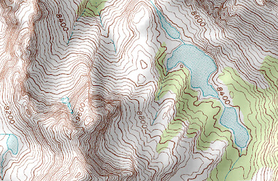
Unlike a planimetric map, topographic maps are very useful for seeing elevational differences between two spots on the same map. That is just what these maps are for: topographic maps use contour lines as well as three-dimensional shading relief to show the elevation of geographic features. This map, where elevation exceeds 9600 ft, is directly from a web article about topography and its use in cartography. Here we can not only see where there are hills or mountains from the look of raised features but also from the contour lines.
Unlike a planimetric map, topographic maps are very useful for seeing elevational differences between two spots on the same map. That is just what these maps are for: topographic maps use contour lines as well as three-dimensional shading relief to show the elevation of geographic features. This map, where elevation exceeds 9600 ft, is directly from a web article about topography and its use in cartography. Here we can not only see where there are hills or mountains from the look of raised features but also from the contour lines.

Jasa survey topografi layanan jasa survey indonesia
ReplyDeleteJasa Survey Topografi
ReplyDeleteFor Contour and construction situation
Jasa Survey Konstruksi Thank For your Informations
ReplyDelete